The Massifs
Although they occupy less than 9% of the MRC of Brome-Missisquoi’s territory, the most important massifs of the region (Sutton, Glen, Foster and Brock) share the remarkable quality of integrating themselves in most of the landscapes here, no matter where we look.

The Massifs, as Far as the Eye can See
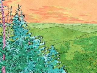
This series of mountains, spanning from Abercorn to Bolton-Ouest, by way of Sutton, marks the boundary between the Appalachian Foothills and the Appalachian uplands. They constitute some of the highest mountains of southern Quebec and can be seen from kilometres away. The northern slopes of the Round Top, culminating at 962 metres, has been home to the Mount Sutton ski resort for more than 60 years.
These Giants and their 360 Million Candles
Logan’s Fault, an earth fracture that runs from Lake Champlain to the Gulf of St. Lawrence, is partly responsible for the formation of the Appalachian Massifs which proudly reign over the Brome-Missisquoi landscape, right at the U.S. border.
More than 360 million years ago, continental islands collided with North America. At the time, the resulting mountains resembled our Canadian Rockies, or perhaps the Swiss Alps. Consisting mainly of basalt, shale and other rocks formed by the consolidation of sediments, these overlapping zones have, over the years, endured the effects of winds and different glaciation phases. Multiple erosions eventually gave them their rounded appearance we know today.

A Relief Preserving the Landscape
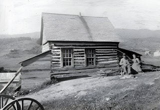
The impressive relief of the Appalachian Massifs discouraged settlers from establishing a strong agriculture. Even the forest industry was only minimally maintained here. During the colonial period of the 18th century, the only way to reach the Missisquoi Valley, which cuts through the heart of the Green Mountains, was by boat from Vermont. And then, only when the water level was high enough.
It wasn’t before the 19th century that a small pass between Abercorn and the valley (now Scenic Road in Sutton) offered a road connection to Highwater. Still today, the remoteness of the area contributes to preserving its exceptional landscape with its succession of hamlets, railways stops, pastures and commemorative places (cemeteries, event markings).

Two Visions for One Identity
The Appalachian Massifs have been attracting tourists for more than a century. Already, in 1860, the postal service stagecoach, linking Saint-Jean-sur-Richelieu to Troy, Vermont, had begun picking up passengers to take them to the foot of the mountains. A few years later, in 1871, the railways took over. And, long before downhill skiing became one of the region’s most important tourist engines in the early 1960s, cross-country skiing and snowshoeing were well-established activities in the area.
Over time, other activities such as hiking, ecotourism and cycling were introduced, making the region even more appealing. This, however, brought about several confrontations between stakeholders in favour of promoting tourism offers and those more worried about preserving the landscapes… And yet, each of these groups has contributed to the sector’s contemporary identity.

The Protection of unique Ecosystems
The Sutton mountain range, Glen Mountain, Mount Foster … increasingly, the slopes of the Appalachian Massifs are being taken over by the dynamics of residential and resort developments. This results in the clearing of forestland to ensure a view of each new property.
These vast landscapes already make up nearly a quarter of the MRC of Brome-Missisquoi’s zones where urban sprawl is being felt. And the pressure is mounting. The situation is threatening for a panoply of environments and the survival of many rare species. Hence, the challenge of establishing a clear development and preservation vision in order to protect these unique ecosystems.
About this, the Sutton Mountains and Mount Echo landscapes shelter more than 60 km2 of preserved environments which represents the vastest privately owned zone protected territory in southern Quebec.